Evacuation Order Lifted In Yolo County
9 p.m. Update: The evacuation order for the area northeast of the community of Yolo has been lifted. All residents are encouraged to remain aware and to sign-up to receive emergency notifications via Yolo-Alert.org.
---
4:50 p.m. Update: Yolo County OES has released an evacuation route map.
Evacuations are in place for north of Cache Creek to CR 13 and between Highway 113 to CR 97.
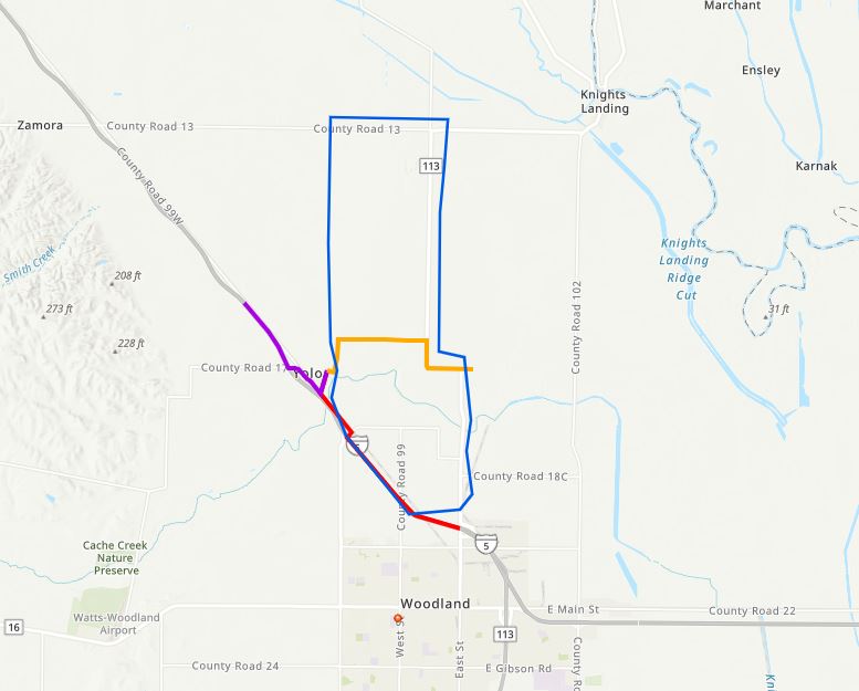
You can view the interactive map here.
A shelter has been established at Lee Middle School in Woodland for evacuees.
YOLO (CBS13) — The Yolo Fire District has issued evacuations for about 100 residents in the area between Highway 113 and County Road 98, as well as CR 98 and CR 18 near Yolo.
According to the Department of Water Resources, the evacuations are due to levee overtopping, which is causing erosion. The levee has not broken.
Cache Creek is now at a danger stage in Yolo County and authorities were investigating reports of overtopping.
The Department of Water Resources forecasted Cache Creek would enter a danger zone where water levels are at or above design levels. Runoff is the result of an atmospheric river rolling through NorCal.
Crews were working Wednesday afternoon to pack sandbags and place them along soft spots that are at risk overflowing.
This is a developing story and will be updated with information as it becomes available. Check back for more.