Powerful Storm Expected To Hit Drought-Stricken California On Tuesday
SACRAMENTO (CBS13/AP) - A Pacific storm system fueled by a plume of subtropical moisture headed toward California on Monday, triggering warnings of widespread rain that could unleash mudflows even as it brings much-needed snow to the drought-stricken state.
Rain was expected to begin falling Tuesday, although the timing of the heaviest downpours was variable, according to the National Weather Service.
WEATHER ON THE GO: Download the CBS Sacramento Weather App
Storm watches were posted for a large swath of the Sierra Nevada, where a huge amount of the state's water supply is normally stored as snowpack. Significant accumulations were predicted but not enough to be a drought buster.
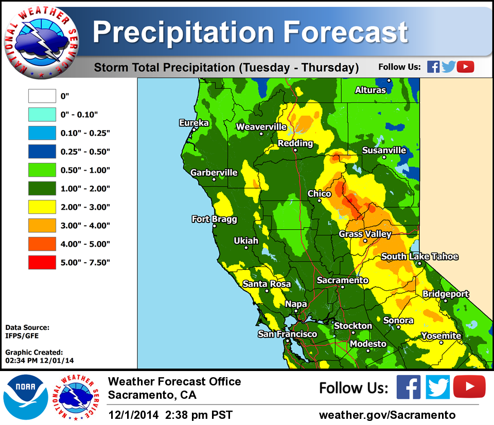
Any delight over the prospect of beneficial precipitation was tempered by concerns about the threat of debris flows from the many areas of California where wildfires have burned away vegetation that would keep soil stable.
A weak storm Sunday was enough to block Pacific Coast Highway west of Malibu with a flow of mud from a section of the steep Santa Monica Mountains denuded by a 44-square-mile fire last year.
"It's pretty loose terrain around here. When it gets wet, it comes down," motorist Joshua Nelson told KCAL-TV.
Residents placed sandbags to protect properties in foothill cities northeast of Los Angeles, where some communities below steep mountains have long lived with concrete barriers lining streets in hopes of keeping debris flows out of homes.
Glendora resident Cory Hansen piled sand bags around his home.
"Hundreds, hundreds of them," he told KABC-TV. "We keep going down to the city yard picking up more, as much as we can. We don't know what's going to happen in the next few days."
Back-to-back storms are helping some cities in northwest California reach normal rainfall amounts for the year, or even better, but the reservoirs and Sierra snowpack that provide much of the state's water remain far short of what they should be, after three years of intense drought.
Redding, 220 miles north of San Francisco, reached 124 percent of normal rainfall by Monday after the weekend storms, National Weather Service forecaster Eric Kurth said. To the south, San Jose stood just a third of an inch shy of its normal 2.89 inches for the period, forecaster Austin Cross said.
For California's water supply, however, it's the Sierra snowpack that counts, Kurth said. And that remains significantly below normal, though much better than last year.
The state Department of Water Resources reported the snowpack was at 24 percent of normal for this time of year as of Monday.
Rain so far, at this early point in California's wet season, has yet to make much of an impact on the state's main reservoirs. Lake Shasta and Lake Oroville have less than 50 percent of their usual water level for the start of December, while Folsom Lake stands at 59 percent, Kurth said.
"Certainly we're quite a bit wetter than we were last year, especially to the north," he said. But "we're not seeing huge storms."
"The good news is there's more storms on the way," Kurth said.
Copyright 2014 The Associated Press.