Dixie Fire Burns More Than 960K Acres
BUTTE COUNTY (AP/CBS13) — The latest on the Dixie Fire impacting Butte, Plumas, and Lassen counties.
The fire remains at 65 percent contained, having burned 960,213 acres.
Overnight, Cal Fire reported calm winds and humidity which helped moderate the flames. Fire activity was minimal due to temperatures dropping into the 30s.
For current evacuation statuses, visit: https://tinyurl.com/2whbc9xn
Previous day's (Sept. 11) updates below:
As of Sunday morning, the fire has burned 959,253 acres and is 62 percent contained.
Previous day's (Sept. 9) updates below:
10 p.m.
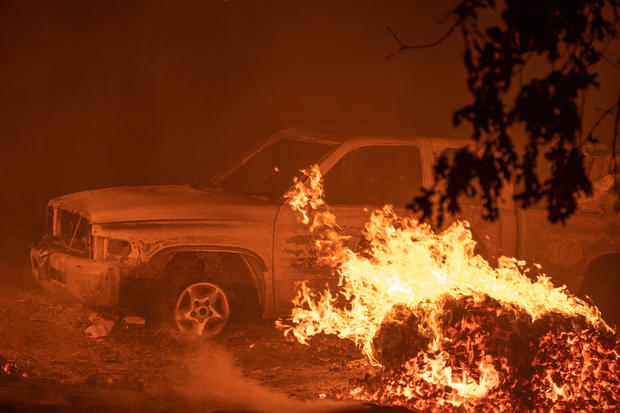
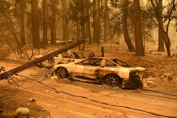
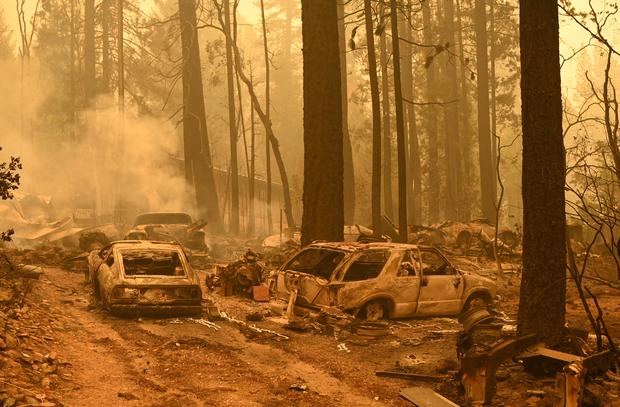
Containment of the Dixie Fire remained steady at 59% as the fire grew to more than 928,000 acres. More than 2,100 hundred structures remain threatened, while 1,329 have been destroyed.
12:11 p.m.
Several more evacuation orders and warnings in Lassen County have been downgraded.
Cal Fire says the follow areas have had their mandatory evacuation orders reduced to warnings:
-East of Hwy 395 (lake side) from the Flux Rd intersection south to County Rd A26 Garnier Rd north to Long Valley Creek LAS-E008B AND LAS-E002-C
-West of Hwy 395 from the intersection of Milford Grade south to Flux Rd, West to Plumas/Lassen County line. LAS-E009B/C
Evacuation warnings have also been lifted in the following areas:
-East of Hwy 395 from the Thunder Mtn Rd intersection south to Milford Grade intersection LAS-E011-A
7:52 a.m.
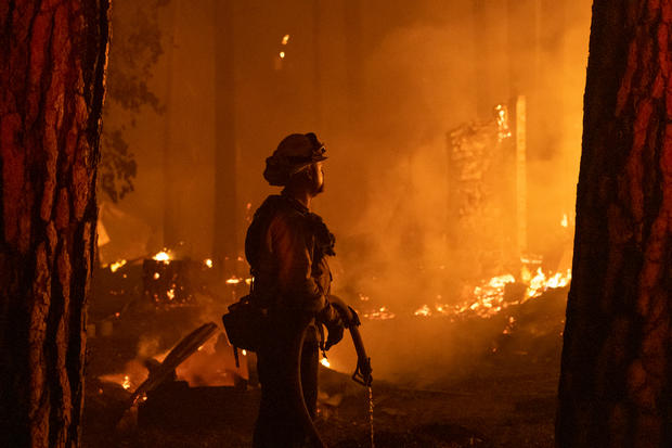
Even with containment rising, the Dixie Fire is still dangerous enough to prompt evacuation orders.
Wednesday night, the Old Station area in the west zone of the Dixie Fire was given a mandatory evacuation order. Winds are continuing to increase fire activity, so Cal Fire says additional resources are being assigned to the Shasta sector to reinforce lines.
As of Thursday morning, the Dixie Fire has grown to 927,320 acres and 59 percent containment.
Cal Fire stresses that a Fire Weather Watch remains in effect through Friday as thunderstorms and winds are expected.
Previous day's (Sept. 8) updates below:
11:00 p.m.
More evacuation orders were issued for Lassen and Shasta counties.
Shasta orders apply to the following areas.
- The community of Old Station in Eastern Shasta County.
- Residents of all roads between the Lassen National Park entrance and the Bridge Campground, as well as residences on Highway 44 from the Lassen County line.
Lassen orders are for the following areas:
- North of Highway 44 from the Lassen County line east to Pitville Road and north to Blacks Mountain/Forest Services Route 32NO2
2:04 p.m.
Several new areas in Plumas County have had their evacuation orders and warnings downgraded.
The following areas are no longer under a mandatory evacuation order:
Taylorsville [PLU Zone 15A]
ALL OF GENESEE VALLEY, southeast of Taylorsville up the Genesee Rd to just south of Babcock Crossing, Walker Mine Road, north portion of Beckwourth Genesee Road. [PLU Zone 28]
Evacuation warnings have also been lifted for the following areas:
Canyon Dam [PLU Zone 5C]
Crescent Mills [PLU Zone 014A]
North side of Chandler Road from Quincy Jct. Rd east to Hwy 70 and the north side of Hwy 70 from Chandler Rd east to just west of Massack.[PLU Zone 17-C and 17-D]
Peters Creek Area, North Arm [PLU Zone 18B]
Heart "K" Ranch, Includes Taylor Diggins Mine, north to Engel Mine, east to Lower Lone Rock, south to the border to Zone 28, west to the Taylor Diggins Mine [PLU Zone 020]
Hwy 70 at Massack, east to the east side of Lee Summit and everything north of those locations to the area of Argentine Rock and the south boundary of Zone 21. This includes Greenhorn and the north side of Spring Garden. [PLU Zone 22-A]
Moonlight Valley, Engel Mine, Lone Rock Valley, and a portion of Fruit Growers Blvd. [PLU Zone 29]
North side of Hwy 70, east of Lee Summit to Hwy 70 at Mohawk Vista. [PLU Zone 32A]
North side of Hwy 70, from Mohawk Vista, east to Willow Creek Road, north to Penman Peak. [PLU Zone 36A]
North side of Delleker. Hwy 70 at Willow Creek Rd, east to Hwy 70 at West Street (Portola) and everything north to Smith Peak.[PLU 36-C]
North side of Beckwourth. North side of Hwy 70 from County Rd A23, east to County Rd A24 and north toward Table Rock.[PLU 42-C]
North side of Portola. Hwy 70 at West Street east to Hwy 70 at A23 (Beckwourth-Calpine Road) and everything north to the southern edge of 35-B (south of Lake Davis) [PLU 42-D]
North side of Hwy 70 from A24 east to Harrison Ranch Rd including Maddalena Rd and the Buttes [PLU 44B]
10:35 a.m.
The Dixie Fire has now grown to 922,192 acres and 59 percent containment.
Several areas in Lassen County have also seen the evacuation warnings get lifted Wednesday morning:
Herlong area north of County Rd A25 from Long Valley Creek east to Pole Line Rd - Zone LAS-E053-B
Herlong Proper south of County Rd A25 from Long Valley Creek east to Sierra Army Depot and south to County Rd A26, including all residences accessed off of County Road A26 - Zone LAS-E002-B
Janesville and Milford west of Hwy 395 from Janesville Grade south to Raker Place Zones LAS-E012-F, J LAS-E010-G&H, D, E, I
North Doyle area west of Hwy 395 from the County Rd A26 intersection south to Bernice Ln and all roads accessed by Pickens Rd – Zones LAS E001-C, D, E
Previous day's (Sept. 8) updates below:
10:24 p.m.
The Dixie Fire has increased in size to 919,300 acres and is 59 percent contained.
7:52 a.m.
The Dixie Fire has now grown to a total of 917,579 acres, Cal Fire reported Tuesday morning.
Containment is now also up to 59 percent.
No date of expected full containment has yet to be given.
Firefighters remain concerned over the hot daytime temperatures expected the next several days. More than 500 fresh firefighters arrived on Monday to help, Cal Fire says.
Previous day's (Sept. 6) updates below:
8 a.m.
The Dixie Fire has now pushed past a total of 900,000 acres.
As of Monday morning, Cal Fire reports that the Dixie Fire has grown to a total of 910,495 acres.
While the fire is still seeing jumps in size, containment has also now grown to 57 percent.
Firefighters say the southeastern part of the wildfire is the area still seeing extreme fire behavior. It's spreading in very dry fuels - and with more hot and breezy weather expected this week, firefighters remain concerned.
Numerous evacuation orders and warnings remain in place.
Previous day's (Sept. 5) updates below:
As of Saturday morning, it has burned 893,852 acres and remains at 56 percent contained.
Just after 12:30 p.m., the Plumas County Sheriff's Department lifted the following evacuation warnings:
- Caribou Rd north to the Humbug Rd and Humboldt Rd intersection. This includes Belden Reservoir and Butt Valley Reservoir [PLU Zone 3]
- The community of Seneca south to Hwy70 [PLU Zone 4A]
- Long Valley and north of Seneca areas [PLU Zone 4B]
- Humbug Road from the intersection of the Humbug-Humboldt Road west to the Butte County line and everything south of the Humbug Road [PLU Zone 6]
- Hwy 36 south to the west side of Hwy 89, including Mud Lake, Soldiers Meadows, and Shanghai Creek area, south to Humbug Road, and west to Butte County line [PLU Zone 6A]
- From the Hwy 89/Hwy 36 Junction, north along Stover Mountain Road to the County Line, and west from the Hwy 89/Hwy 36 Junction along the south side of the highway to the county line [PLU Zone 7]
- Chester Juniper Lake Road north, Hwy 312 northwest, Forest Road 28N61 north west [PLU Zone 8A]
- Manzanita Mtn. Echo Lake areas. North of Hwy 36 [PLU Zone 38 A]
Previous day's (Sept. 4) updates below:
11:34 p.m.
The Dixie Fire has burned 889,001 acres and is 56 percent contained. Read more on Cal Fire's Twitter account.
Authorities announced Saturday that a Lassen National Forest firefighter battling the Dixie Fire had died earlier this week because of an illness.
10:30 a.m.
Containment remains at 55 percent with 885,954 acres burned as of Saturday morning.
Overnight, the fire activity in the west zone of the fire was limited to lower intensity ground fire, according to a report from firefighters with the Plumas National Forest.
Additionally, heavy material continued to smolder and consume itself, in part because of the limited humidity recovery in the mid and higher elevations.
Today, the inversion is expected to begin to set in, keeping more smoke in the fire area. Interior islands will continue to burn out and create short-range spotting if near the control lines. Temperatures will continue to rise through the weekend with relative low humidity.
On Friday, wind-driven flames pushed out of the southeast end of the fire. As a result, crews worked overnight to protect structures in Dixie Valley and build line, keeping pace with the fire as it progressed towards Rose Canyon, according to the report.
Crews will continue more of this work today to protect Dixie Valley, while other resources will aim to protect the Highway 70 corridor.
Structure protection continues within the communities of Clover Valley, Genesee, Taylorsville, Greenhorn and Cromberg.
9:30 p.m.
The Dixie Fire grew by nearly 13,000 more acres since Friday morning, now reported at 881,086 acres burned. Containment remained at 55%.
8:05 a.m.
The Dixie Fire has now grown to 868,781 acres as of Friday. Containment has also now jumped to 55 percent, Cal Fire reports.
In total, over the course of the fire, 1,282 structures have been destroyed. Of those, 688 were homes.
There is still no estimated date of full containment.
Previous day's (Sept. 2) updates below:
12 p.m.
As of Thursday morning, the Dixie Fire has grown to 859,457 acres and is 55% contained. There are 4,039 people battling the fire.
The Red Cross has issued an updated list of shelters for the Dixie Fire.
Previous day's updates below:
7:35 a.m.
The Dixie Fire is still seeing explosive growth, even as containment slowly rises.
As of Wednesday, Cal Fire reports that the Dixie Fire is now a total of 844,081 acres. It started Tuesday morning at just over 800,000 acres.
Containment is now up to 52 percent.
Firefighters are continuing to battle warm temperatures and high winds.
Previous day's updates below:
7 p.m.
The Dixie fire has grown to 819,956 acres, which is nearly 20,000 acres larger than it was at 7 a.m. Tuesday. There are 688 residences that have been destroyed with another 52 that have been damaged.
Containment of the fire has grown to 49%.
Wind speed and temperatures are expected to decrease overnight.
12:37 p.m.
New evacuation warnings have been issued in Lassen County due to the Dixie Fire.
The following areas are now under evacuation warnings:
Milford area east (lake side) of Highway 395 from the Thunder Mountain Road intersection south to County Road A26/Garnier Road.
Officials note that the evacuation warning area includes the south side of County Road A25 east to not including Sierra Army Depot Zones LAS-E011-A, E008-A, E002-B, C.
12:10 p.m.
The Dixie Fire surpassed a grim milestone on Tuesday, with its size now more than 800,000 acres.
In total, Cal Fire says the Dixie fire is now 807,396 acres. It is also still 48 percent contained.
Like with the Caldor Fire to the south, firefighters remain concerned about winds. The Red Flag Warning for the Sierra has been extended through Wednesday.
Previous day's updates below:
11:28 p.m.
The Dixie fire stands at 777,741 acres and is 48% contained. It has destroyed 685 single structures and is threatening 13,614 structures.
A new evacuation order and warning were issued Monday.
Previous day's updates below:
7:53 a.m.
The Dixie Fire continued its growth even as firefighters aggressively battled back flames.
As of Monday, Cal Fire reports that the wildfire has now grown to a total of 771,183 acres. Containment has also slightly risen to 48 percent.
Like with the Caldor Fire further south, firefighters are watching the wildfire closely on Monday as a Red Flag Warning is set to go into effect. Wind gusts and low relative humidities are expected through most of Tuesday night.
Previous day's updates below:
An evacuation warning has been lifted for the following area.
Previous day's updates below:
8:25 a.m.
As the Dixie Fire continues to grow in spurts, containment is also now ticking up.
As of Friday morning, Cal Fire reports that the wildfire is now a total of 750,672 acres. Containment is now up to 46 percent as well.
Firefighters say they are continuing to battle spot fires, including a spot fire on top of Grizzly Ridge. Crews will be continuing to try and keep that spot fire from moving west.
Previous day's updates below:
10:00 p.m.
Containment on the Dixie Fire remained at 45% throughout the day while the flames continued to spread, now burning 749,713 acres.
Nearly 12,000 structures remain threatened.
10:57 a.m.
The Dixie Fire has now grown to 747,091 acres as of Thursday morning, Cal Fire reports.
New evacuation warnings have now also been issued in Plumas County.
The following areas are now under an Evacuation Warning:
-North side of Chandler Road from Quincy Jct. Rd east to Hwy 70 and the north side of Hwy 70
from Chandler Rd east to just west of Massack. [PLU Zone 17-C and 17-D]
-Hwy 70 at Massack, east to the east side of Lee Summit and everything north of those locations to the area of Argentine Rock and the south boundary of Zone 21. This includes Greenhorn and the north side of Spring Garden. [PLU Zone 22-A]
Cal Fire says the wildfire remained active well into the night. While temperatures are expected to increase on Thursday, forecasters say winds will be decreasing.
Previous day's updates below:
9:10 p.m.
The Dixie Fire is nearly three-quarters of the way to one million acres burned. According to Cal Fire, the blaze has scorched 742,724 acres while containment remained at 45% as of Wednesday night.
Nearly 700 homes have been destroyed while more than 11,800 remain threatened. Another 52 homes suffered some damage.
Only three injuries have been reported so far in the Dixie Fire battle—all three are first responders, according to Cal Fire.
2:53 p.m.
The east zone of the Dixie Fire has started to intensify again Wednesday afternoon, firefighters say.
Crews report seeing a visible column developing over Grizzly Peak as the Dixie Fire continues its growth.
While tankers have been flying over the wildfire for most of the day, firefighters are still trying to hold the flames to the north of Grizzly Peak.
With the fire advancing, crews are continuing to prepare to hold the community of Taylorsville - who only saw its evacuation orders upgraded from warnings to orders over the weekend.
11:54 a.m.
The Dixie Fire has continued to grow, but at a much slower pace.
As of Wednesday morning, Cal Fire reports that the wildfire is now 735,064 acres.
Containment has also crept up to 45 percent.
Firefighters say winds continued to keep the fire active overnight, but humidity levels also rose and helped reduce spotting.
No date of expected full containment has been released at this point.
Previous day's updates below:
10:25 p.m.
The Dixie Fire grew slightly into Tuesday night, now recorded at 733,475 acres at 43% containment.
The fire, which has been burning for 41 days, has destroyed 1,273 structures and damages 92 more.
8:46 a.m.
The Dixie fire is now 731,310 acres in size and 41% contained.
Previous day's updates below:
11:15 p.m.
The Plumas County Sheriff's Office lifted some evacuation warnings Monday. Those areas are:
- [PLU Zone 001] High Lakes recreational area of Plumas County east of the Butte/Plumas County line to include Rock Creek Power Generation Facility, and the Highway 70 corridor.
- [PLU Zone 002A] South side of Highway 70 to include the communities of Tobin, Rogers Flat, Storrie, Virgilia, Twain, Grays Flat, Hot Springs, to the southern portion including Lower Bucks and all of Bucks Lake, and Silver Lake.
- [PLU Zone 005A/B] Entire west shore of Lake Almanor to include Canyon Dam boat ramp (EXCLUDES TOWN OF CANYON DAM [PLU Zone 005C), Big Meadows, Prattville, Almanor West, entire Hwy 89 corridor from Hwy 147 to Hwy 36.
- [PLU Zone 008B] Chester proper, EXCLUDING WARNER VALLEY.
- [PLU Zone 009] Lake Almanor Peninsula, Hamilton Branch.
- [PLU Zone 12A/B] South of Highway 70, Butterfly Valley, including Keddie, Round House Road, Old Highway, Paxton, Black Hawk Road, Elizabeth Town, Gopher Hill, Snake Lake, Snake Lake Road.
8:38 a.m.
The Dixie fire has grown to 725,821 acres overnight and is 40% contained. The fire has destroyed 1,259 structures, including 678 single residences.
Previous day's updates below:
Containment improved overnight Saturday. The fire is now 721,298 acres with 37 percent contained.
While fire remained active for most of the night, increased humidity in the early morning hours slowed fire activity and flames did not threaten current control lines. Firefighters say they expect a much milder weather patter today and into the middle of next week.
Since the fire started on July 13, a total of 1,247 structures have been destroyed, including 670 single residences, according to the latest Cal Fire incident report.
Previous day's updates below:
9:00 p.m.
The Dixie Fire grew slightly into Saturday night. It has now burned 717,308 acres while containment bumped up to 36 percent.
The fire has been burning for 38 days now.
5:10 p.m.
More evacuations were ordered in Plumas County for the following area:
- Sugar Loaf [PLU Zone 43a]: Frenchman Road near Bloomer Lake Road, north to the county line, and the Plumas side of Doyle Grade.
12:59 p.m.
As of Saturday morning, the fire is was at 714,219 acres with no change in containment.
The number of structures destroyed is now at 1,230.
At noon, the Lassen Sheriff's Office issued mandatory evacuation orders for:
Previous day's updates below:
7:30 p.m.
The Dixie Fire slightly grew into the evening, now recorded at 705,000 acres with no change in containment.
With the growth came more evacuation orders. The community of Taylorsville was again under a mandatory evacuation order due to an imminent threat from the flames, the Plumas County Office of Emergency Services announced. This includes Arlington Road and Nelson Street. Evacuees were advised to head toward Quincy.
Also under evacuation orders was east side of Mt. Hough, east to Tower Rock and the south edge of Genesee, including Emigrant Road. Authorities said there is no indication of population in the area, but anyone there should leave immediately.
Shelters are set up at Springs of Hope Church at 59 Bell Lane in Quincy, Holy Family Catholic Church at 108 Taylor Ave in Portola ana Veterans Memorial Hall at 449 W Sierra Ave in Portola.
Anyone who needs assistance with animals is advised to contact Plumas County Animal Services.
3:15 p.m.
The Dixie Fire has now scorched 700,630 acres as of Friday afternoon. Containment remained at 35%.
The number of structures destroyed is now at 1,225, including more than 650 homes.
The only wildfire in state history that has burned more land than the Dixie Fire is the August Complex—which burned 1,032,648 acres in 2020.
7:56 p.m.
Thursday evening, the Dixie Fire nearly reached another milestone: the 700,000 mark. The fire has now grown to burn 699,666 acres. It was still 35% contained.
Cal Fire said 651 single residences, 8 multiple residences, and 137 commercial structures have now been destroyed.
11:41 a.m.
Residents of Rush Creek Road in the Feather River Canyon can return home starting today (8/19). This area is deemed safe from fire and trees that may pose a hazard. Residents are urged to stay on Highway 70 to return and follow directions from public safety officials.
For more information, visit www.plumascounty.us and follow the county Facebook page.
8:30 a.m.
The Dixie Fire has grown to 678,369 acres and is 35% contained.
It continued to burn actively for most of the night as humidity lowered and winds were sustained. Low fuel moistures and terrain-driven winds continued to fire growth.
The number of single residences that were destroyed is 649. Sixty are damaged.
Previous day's updates below:
1:14 p.m.
Some evacuation orders for the Dixie Fire have now been reduced to warnings.
The reduced orders are some parts of Tehama and Plumas counties.
For a detailed list of the changes, head to this link.
7:35 a.m.
The Dixie Fire continues to grow in large chunks.
As of Wednesday morning, Cal Fire reports that the Dixie Fire has now grown to a total of 635,728 acres. It remains 33 percent contained.
Shifting winds, which also spurred the explosive growth of the Caldor Fire in El Dorado County, continue to be the biggest challenge for firefighters. The winds caused short to mid-range spotting in the Dixie Fire, contributing to the wildfire's steady growth.
Thousands of structures remain threatened, with the total number of homes destroyed now reaching 645.
Previous day's updates below:
8:03 a.m.
Firefighters are again reporting intense fire activity in the Dixie Fire.
As of Tuesday, Cal Fire reports that the Dixie Fire has now grown to a total of 604,511 acres (around 944 square miles). It remains 31 percent contained.
This means that the Dixie Fire is now more than double the land area in size compared to Los Angeles (around 468 square miles). It is also approaching the size of the smallest state, Rhode Island (which is around 1,034 square miles).
Firefighters say the intense fire activity was coupled with a significant change in the weather pattern that Brough southwest winds ranging from 15-25 mph. A Red Flag Warning remains in effect for the area until late Tuesday night.
The number of homes destroyed in the Dixie Fire also continues to increase as damage inspection teams continue surveying the area. As of Tuesday, Cal Fire says a total of 1,180 structures have been destroyed, including 630 homes.
6:52 p.m.
The Plumas County Sheriff's Office has issued a mandatory evacuation order for Dixie Mountain north of the Plumas Lassen County line, including Jordan Flats, Ferris Flat, Fitch Canyon, and Cottonwood Mountain. Residents are urged to leave the area immediately.
5:52 p.m.
EVACUATION WARNINGS
East of Hwy 395 from Baxter Creek south of Sunnyside Rd not to include Sunnyside Rd south to the Herlong Access Rd A25
West of Hwy 395 from Milford Grade to the intersection of Herlong Access Rd A25.
There is also a new mandatory evacuation order for Janesville west of Highway 395 from Janesville Grade south to Mill Street just before Milford Grade.
7:55 a.m.
The now more than month-old Dixie Fire continues to be a threat, especially with winds and extremely high temperatures in the forecast for Monday into Tuesday.
As of Monday morning, Cal Fire reports that the wildfire has burned 569,707 acres.
Containment remains at 31 percent.
Temperatures are expected to cool off into near seasonal averages on Tuesday, but Monday is expected to be in the triple digits. A Fire Weather Watch has also been posted by the National Weather Service for Tuesday night into Wednesday for much of the Sacramento Valley and foothills due to gusty winds.
A host of evacuation orders and warnings remain in effect near the Dixie Fire.
Previous day's updates below:
11:10 p.m.
While containment remained steady at 31%, the Dixie Fire grew to 570,211 acres.
The largest wildfire currently burning in the United States has now been burning for 32 days.
10:54 a.m.
Overnight, the fire grew by more than 14,000 acres as thunderstorms pushed flames closer to two towns not far from where the Dixie Fire last week destroyed much of the small town of Greenville.
On Sunday morning, containment remained at 31 percent.
To date, the fire has destroyed 615 residences and damaged an additional 46, although assessments are still underway, according to Cal Fire.
Another 14,838 structures are still threatened.
10:19 a.m.
The Plumas County Sheriff's Office has issued new mandatory evacuation orders for the unpopulated area of Babcock Crossing, Elephants Playground and Murdock Crossing.
This includes Beckwourth-Genesee at Clover Creek Loop, North to area of Drum Bridge, North to area of Babcock crossing. East to Big Flat Spring, South to25N05, West to Beckwourth Genesee road. [PLU 31 Zone]
This zone is south of Antelope Lake and north east of Genesee Valley. A map can be viewed at https://tinyurl.com/ydrapp24
If you are in this area, you should evacuate to the south, to the Holy Family Catholic Church at 108 Taylor Ave, Portola.
9:34 a.m.
The Plumas County Sheriff's Office has announced it will escort previously evacuated residents into the areas of Indian Valley, Greenville, Canyon Dam, West Shore, Warner Valley and the greater Chester area once it has been rendered safe.
Those seeking an escort will need to confirm they have an affected structure by filling out an online form at https://tinyurl.com/ynv5b6b4 or by calling 530-283-6414. The phone line will be active from 9 a.m. to 4 p.m. daily through Wednesday.
Previous day's updates below:
7:40 a.m.
As of Saturday morning, it is 540,581 acres with 31 percent contained.
Crews were cutting back brush and using bulldozers to build lines to keep the Dixie Fire from reaching Westwood east of Lake Almanor, not far from where the lightning-caused blaze destroyed much of the town of Greenville last week.
Previous day's updates below:
7:50 p.m.
More mandatory evacuation orders have been issued in Plumas County as the Dixie Fire rages on.
According to the Plumas County Sheriff's Office, the order applies to all of the Genesee Valley, southeast of Taylorsville up Genesee Road to just south of Babcock Crossing, Walker Mine Road, and the north portion of Beckwourth Genesee Road.
An evacuation shelter is set up in Quincy at Springs of Hope Church at 59 Bell Ln.
12:10 p.m.
The Plumas County Sheriff's Office says there are four people who are unaccounted for in the areas of Chester and Greenville -- two areas hard-hit by the destructive Dixie Fire.
On Friday at 11:30 a.m. the sheriff's office released a statement identifying the following people as missing:
- Alan Kuhl of Chester
- Ronald Avila of Greenville
- Raymond Hunt of Greenville
- Irene Andrews of Greenville
The sheriff's department is asking for the public's help to locate these people. If you are one of these people, or if you know of their whereabouts, you are asked to call the sheriff's office at (530) 283-6300.
9:30 a.m.
The plan to repopulate the following Plumas County areas has been canceled out of "extreme caution", the California Department of Forestry and Fire Protection says.
- Big Meadows
- Rocky Point Campground
- Canyon Dam Boat Launch
Visit the Plumas County website for more information.
8:12 a.m.
The Dixie Fire has now grown to 517,945 acres as of Friday morning.
Containment has also crept up to 31 percent, Cal Fire reports.
Firefighters say thunderstorms and triple digits temperatures are predicted on Friday, which could complicate the battle. Further, damage to fiber optic lines has caused some intermittent issues with 911 in Lassen County.
Crews battling the west zone of the Dixie Fire expect it to continue to burn as the flames are in remote areas with limited access.
In the east zone of the fire, firefighters are reporting that the flames have continued to back down. At one point, Cal Fire reports that 40,000 gallons of ground-based fire retardant was used for structure protection in Keddie Ridge.
Numerous evacuation orders and warnings remain in effect.
Previous day's updates below:
9:08 a.m.
Officials are getting a clearer picture of the destruction left by the Dixie Fire as it continues to grow.
As of Thursday, the wildfire is now at 510,227 acres. Containment is holding at 30 percent, the same number it was on Wednesday.
A more detailed breakdown of the homes destroyed in the Dixie Fire was released yesterday, but Cal Fire says they are still surveying areas. With that in mind, Cal Fire says a total of 584 homes have been destroyed - up from the 557 number reported on Wednesday.
Firefighters remain concerned over high temperatures and windy conditions for the west zone of the fire. Thunderstorms are also predicted later in the day.
Previous day's updates below:
3:55 p.m.
The Plumas County Sheriff's Office has downgraded some mandatory evacuation orders to warnings. Those areas are:
- High Lakes Recreational Area
- Feather River Canyon, from the Butte/Plumas County Line east to Twain, not including Rust Creek
- Butterfly Valley, Keddie to Hwy 70 at Black Hawk Rd and Snake Lake, including Spanish Creek Campground, Round House Rd, Old Highway
- East side of Keddie, Round House Road and Old Highway
- Hwy 70 at Black Hawk Rd, south to Barlow Rd and everything west to Snake Lake
- Mt. Hough
Additionally, the following areas have been removed from the evacuation warnings list:
- Bucks Lake from the eastern intersection of Big Creek Rd and Bucks Lake Rd, west to the Plumas/Butte County Line. Everything south of the fire perimeter to the area south of Big Creek Rd and south of the western portion Bucks Lake
- Chandler Road; including American Way, Pine Oak Lane, Amity Lane, Hillside Dr, Oakland Camp Road.
- Grizzly Mountain, south of Genesee Valley to 24N16 Road and east to the 25N42 intersection with Beckwourth Genesee Rd
- Meadow Valley, Bucks Lake Rd at Riverdance west to the eastern intersection of Bucks Lake Rd and Big Creek Rd.
8:06 a.m.
While containment has slowly begun to increase, the Dixie Fire has also now grown to over 500,000 acres.
As of Wednesday morning, Cal Fire reports that the wildfire has burned a total of 501,008 acres. Containment is now up to 30 percent, several points higher than the day before.
Cal Fire also released a more detailed breakdown of the homes destroyed in the wildfire.
A total of 557 homes have been destroyed in the Dixie Fire, with another 8 multiple-residences also destroyed. Commercial buildings destroyed number 131, while another 341 minor structures have also been destroyed.
Firefighters say nearly 15,000 structures remain threatened by the Dixie Fire.
Previous day's updates below:
9:24 p.m.
The Dixie Fire has grown to 490,205 acres and is 27 percent contained. Here's the latest update on progress.
For information regarding the West Zone, visit https://www.facebook.com/CALFIRELMU
1:08 p.m.
A number of Evacuation Orders are now being reduced to Evacuation Warnings.
According to Cal Fire, the following areas were downgraded early Tuesday afternoon:
Butte Meadows area
• Humboldt Rd at Thatcher Ridge
• Up to Cherry Hill Campgrounds
• North to the Butte/Tehama County Lines
Jonesville area
• State Route 32 at the Butte/Tehama County line
• East to the area of Cherry Hill Campground
• Southeast to Snag Lake
• Southwest to Skyway at Bull Creek
• North along Skyway to Humboldt Road
Snag Lake area
• Humbug Summit Rd at the Butte/Plumas County lines
• Southwest across Snag Lake to Humbug Summit Rd and Skyway
• The area surrounding High Lakes Rd near the Carr Mine.
Philbrook area
• Philbrook Lake south to Browns Ravine Rd just east of 25N22
• East to the Butte/Plumas County Lines
The Lassen National Forest remains closed, Cal Fire says.
10:02 a.m.
The Dixie Fire continues to grow, but at a slower pace than before.
As of Tuesday morning, Cal Fire reports that the wildfire has grown to 487,764 acres. It remains 25 percent contained and there is no longer an expected full containment date.
Firefighters say the Dixie Fire remained active overnight, but there is still concern about wind-driven fire behavior to the northeast of the incident.
A total of 893 structures have been destroyed in the fire. It's unclear, at this point, how many of those structures are homes.
Previous day's updates below:
8:47 p.m.
Cal Fire reports that the Dixie Fire has burned 482,047 acres. It is 22 percent contained and has destroyed 873 structures.
Click here for the latest update from Cal Fire.
9:41 a.m.
While the Dixie Fire remained active overnight, there wasn't a big jump in acreage like in previous days.
As of Monday morning, Cal Fire reports that the Dixie Fire has burned 489,287 acres. It remains 21 percent contained.
Numerous Evacuation Orders and Warnings remain in effect.
Previous day's updates below:
9:10 p.m.
The Dixie Fire's rapid growth continued through Sunday night with more than 489,000 acres now scorched, according to Cal Fire. The fire was still only 21% contained.
The number of structures completely destroyed has now grown to 627, while 42 more were damaged. Cal Fire has more than 5,800 personnel assisting in the firefight.
The Dixie Fire—now the second-largest blaze in California history and largest single-fire blaze in state history—has been burning for 25 days.
The largest fire in recorded California history remains the 2020 August Complex Fire, which was comprised of multiple smaller fires and burned across seven counties, destroying 935 structures. It was a total of 1,032,648 acres.
4:08 p.m.
Three more mandatory evacuation orders were issued in Plumas County Sunday afternoon.
Those areas are:
- P Zone 20: Hearth Ranch Includes Taylor Diggins Mine, north to Engel Mine, east to Lower Lone Rock, south to the border to Zone 28, west to the Taylor Diggins Mine.
- P Zone 29: Long Rock includes Moonlight Valley, Engel Mine, Lone Rock Valley, and a portion of Growers Blvd. USFS Rd. 28N32 intersection of Plumas/Lassen line, and east to Diamond Mountain area, south to Lone Rock.
- P Zone 30: includes the area surrounding Antelope Lake, North to the Plumas/Lassen Line as well as East to the Plumas Lassen Line, including Fruit Growers Blvd USFS Road 28N32, Indian Creek Road, Diamond Mountain Way the area of Thompson Creek and Boulder Creek.
The Plumas County Sheriff's Office is advising civilians to evacuate toward Portola by way of Beckwourth Genesee Road. A shelter is set up at Holy Family Catholic Church on 108 Taylor Ave. in Portola.
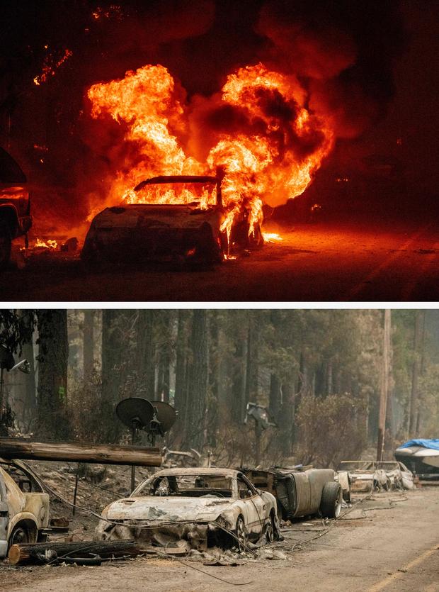
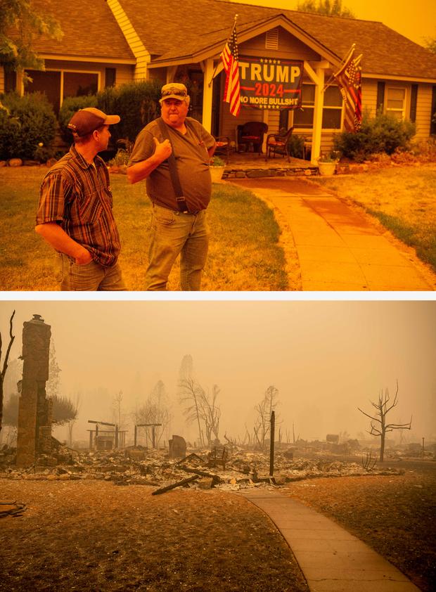
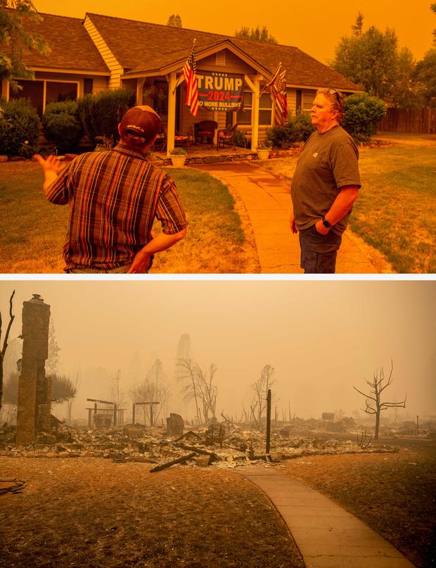
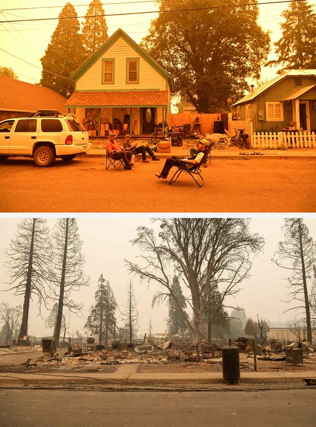
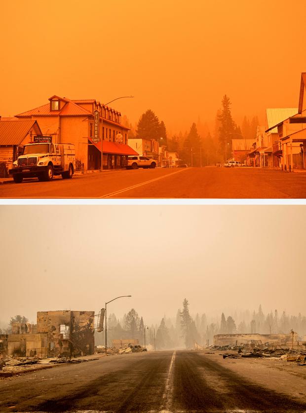
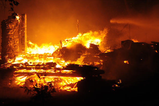
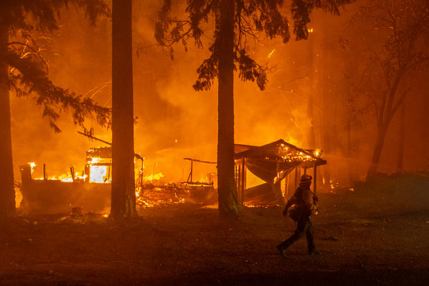
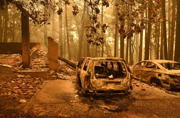
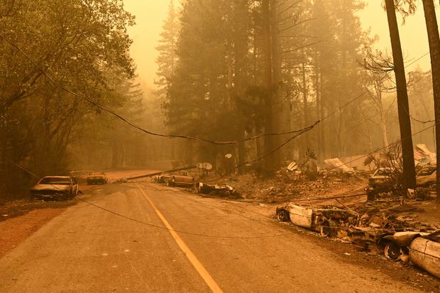
See before-and-after photos below showing some of the destruction the Dixie Fire left behind on its path through the small town of Greenville, which was destroyed in the fire.
2:53 p.m.
The Plumas County Sheriff's Office said there were four people from Greenville who were unaccounted for in the Dixie Fire.
Those four people are:
- Lillian Basham of Greenville
- Joseph Basham of Greenville
- Blanca Auban of Greenville
- Michael Auban of Greenville
Anyone who knows of their whereabouts is asked to contact the Plumas County Sheriff's Office.
8:25 a.m.
The Dixie Fire is now 463,477 acres, making it the second-largest wildfire in California's history and the largest single wildfire in state history. According to Cal Fire, the blaze was still just 21% contained Sunday morning.
A total of 589 structures have been destroyed to date, with another 13,871 still threatened.
On Sunday morning, the Lassen County Sheriff's Office issued new evacuation warnings issued for the Janesville area, west of Highway 395 from Bass Hill to Janesville Grade west to the Lassen County line including the area south of Bass Hill and the dirt portion of Wingfield Rd on the Janesville Side.
Mandatory evacuation orders remain in place for:
- Clear Creek, Westwood, and Pine Town area south of Highway 36 from the Lassen County line east to Moonlight Ranch Rd - Zones LAS-E020 and LAS-E023
- Lassen National Forest south of Highway 36 to the Lassen County line including Hamilton Mtn., Coyote Peak, and Indicator Peak – Zone LAS-E017
- Walker Lake area south of Moonlight Rd. – Zone LAS-E018-19
- Area east of Mtn. Meadows Reservoir and south of Highway 36 to Coppervale – LAS-E026
- North of Highway 36 from the Lassen County Line to A21 - Zone LAS-EO27
- South of Highway 44 from A21 to McCoy Flat – Zone LAS-E028
- North of Highway 36 east of A21 - Zone LAS-EO29
- The area south of Highway 44 from the Lassen County line east to A21 including Silver Lake, Juniper Lake, and the Caribou Wilderness Area - Zone LAS-E031
Evacuation Warnings remain in place for the area south of Highway 44, north of Highway 36, west to Hog Flat Reservoir.
Additionally, County Road A21 is closed to southbound traffic from Highway 44, and Highway 36 is closed west of the intersection of Hwy 44 and 36
Previous day's updates below:
10 p.m.
As of Saturday evening, the Dixie Fire has burned 447,723 acres while containment has remained at 21 percent. Nearly 14,000 structures remain threatened and 370 have now been destroyed, according to Cal Fire.
Two people still remain unaccounted for from the Greenville area.
7:11 a.m.
Overnight, the fire grew by more than 22,000 acres with containment remaining the same. It is now 446,723 acres with 21 percent containment.
The Plumas County Sheriff's Department has reported five people missing, many of those from the community of Greenville that was overcome with flames earlier this week.
Evacuations also remain in effect for a number of small communities threatened by lightning-sparked fires in and around national forests.
With cooler temperatures and calmer winds overnight reducing the flames, firefighters were able to slow the fire's advance northeast. It is now burning in more sparse fuels.
Crews were also able to keep the fire west of Crescent Mills.
Previous day's updates below:
7:19 p.m.
That fast-growing Dixie Fire continued to spread Friday, now burning 434,813 acres. Containment has been sitting at 35 percent for a while, but Friday evening, that number dropped down to 21 percent, according to Cal Fire.
The amount of contained fire line along the fire's perimeter has not changed. However, since the total fire acreage has significantly grown, the percentage of containment has decreased to 21 percent
There are still nearly 14,000 structures threatened by the fire, while 184 have been completely destroyed—including homes.
10:34 a.m.
A host of new mandatory evacuation orders have been issued in Lassen County.
Residents in the following areas are now being told to leave:
• Lassen National Forest south of Hwy 36 to the Lassen County line including Hamilton Mtn., Coyote Peak, and Indicator Peak – Zone LAS-E017
• North of Hwy 36 from the Lassen County Line to A21 - Zone LAS-EO27
• South of Hwy. 44 from A21 to McCoy Flat – Zone LAS-E028
• North of Hwy. 36 east of A21 - Zone LAS-EO29
Numerous other evacuation orders remain in effect in Lassen County due to the Dixie Fire, which is still seeing explosive growth.
9:35 a.m.
Much of the northern Central Valley is covered in smoke Friday morning due to California's wildfires.
According to the National Weather Service, critical fire weather conditions have now passed. However, breezy winds are expected to continue locally through the weekend.
7:01 a.m.
The Dixie Fire continued its explosive growth overnight, with the wildfire now one of the top three biggest ever recorded in California.
On Friday, Cal Fire announced that the Dixie Fire was now 432,813 acres - a jump of just over 100,000 acres since Thursday. Containment is still being reported at 35 percent.
The day before, the Dixie Fire already ranked as the 6th largest fire recorded in California. Friday's numbers, however, mean that it has now overtaken the 2020 LNU Lightning Complex Fire (363,220 acres), the 2020 Creek Fire (379,895 acres), and the 2020 SCU Lightning Complex Fire (396,624 acres).
If the Dixie Fire continues to grow, it appears poised to overtake the 2018 Mendocino Complex Fire in the second spot. That fire burned a total of 459,123 acres.
The largest fire in recorded California history remains the 2020 August Complex Fire. That wildfire - which burned across seven counties and destroyed 935 structures - was a total of 1,032,648 acres.
Previous day's updates below:
7:55 p.m.
The Dixie Fire has grown by nearly 40,000 more acres since Thursday morning, now being reported by Cal Fire as 361,812 acres in size. Containment was still at just 35 percent, the agency said in a Thursday evening press conference.
 More than 5,000 firefighters are battling the blaze, which has ravaged Butte, Plumas and now Lassen counties, forcing thousands of residents from both areas from their homes.
Mop ups of Highway 70 and Butte Road are being performed, Cal Fire said. There was also significant fire growth along Humboldt Road over the last 24 hours with crews trying to contain multiple spot fires.
Evacuation orders were lifted for the town of Greenville, most of which was destroyed by the Dixie Fire this week, leaving homes and other buildings completely leveled. Despite the orders being lifted, people still in the area or nearby areas should be prepared to evacuate immediately if told to do so.
The Dixie Fire's growth Thursday puts it fewer than 1,500 acres shy of surpassing 2020's LNU Lightning Complex Fire as the fifth-largest wildfire in California history.
3:43 p.m.
The Plumas County Sheriff's Office issued another urgent warning that people still in Chester, Hamilton Branch and the Lake Almanor peninsula should evacuate now due to the immediate danger presented by the Dixie Fire.
Evacuees are being asked to head east to Susanville. Shelters are in place at Lassen Community College at 478-200 CA-139 and Lassen High School at 1110 Main Street.
Due to the extreme fire conditions, first responders may not be able to help anyone who stays in those areas, the sheriff's office said.
1:29 p.m.
Several new Evacuation Orders and Warnings have been issued for the Dixie Fire - including now in Lassen County.
The Lassen County Sheriff's Office says the following areas are now under an Evacuation Warning:
• Walker Lake area north of Mtn. Meadows Reservoir and south of Moonlight Rd. – Zone E018
• Area east of Mtn. Meadows Reservoir and south of Hwy 36 to Coppervale – Zone LAS-E026
• North of Hwy 36 from the Lassen County Line to A21 - Zone LAS-EO27
• South of Hwy. 44 from A21 to McCoy Flat. – Zone LAS-E028
• North of Hwy. 36 east of A21 - Zone LAS-EO29
Mandatory Evacuation Orders remain in place for the following areas:
• The area south of Hwy 44 from the Lassen County line east to A21 including Silver Lake, Juniper Lake, and the Caribou Wilderness Area -Zone LAS-E031
• The unpopulated area south of Mountain Meadows Reservoir from Hamilton Branch waterway east to the Lassen/Plumas County line. Zone LAS-E019.
Clear Creek, Westwood, and Pine Town area south of Hwy 36 from the Lassen County line east to Moonlight Ranch Rd- Zones LAS-E020 and LAS-E023
A new mandatory Evacuation Order has also been issued in Plumas County:
Taylorsville and surrounding areas including, North Valley Rd, North Arm Rd and Diamond Mtn. Road.
The sheriff's office says they estimate that about 38 percent of Plumas County residents are under an Evacuation Order.
8:53 a.m.
The Dixie Fire has again exploded in size, growing by nearly 50,000 acres overnight.
Cal Fire reports that, as of Thursday morning, the Dixie Fire has grown to 322,502 acres. It is still just 35 percent contained, the same number it has been stuck at since last weekend.
Firefighters say the extreme fire behavior was fueled overnight by low relative humidity and strong winds.
Numerous evacuation orders remain in effect.
With the acreage jump, the Dixie Fire has now become the 6th largest wildfire in recorded California history. Notably, with the Dixie Fire continuing its explosive growth, 6 of the top 7 largest wildfires have now happened either in 2020 or 2021.
Previous day's updates below:
4:03 p.m.
The Plumas County Sheriff's Office said the community of Chester, adjacent to Lake Almanor, should immediately evacuate to the east. If residents are not able to evacuate and are threatened by the fire, they are advised to take refuge at the Chester High School baseball field.
11:37 a.m.
Evacuation orders are now in effect for parts of Tehama County, specifically St. Bernard's Lodge and Elam-Carter Creek areas.
8:09 a.m.
After an extremely active day that prompted several new evacuation orders, the Dixie Fire has now grown to be the 8th largest wildfire in recorded California history.
As of Wednesday morning, Cal Fire reports that the Dixie Fire had jumped in size to 274,139 acres. This is a nearly 20,000-acre size increase from the day before.
At the start of the week, the wildfire was already the 11th largest in state history - but it has since now topped the 2013 Rim Fire (at 257,314 acres), the 2012 Rush Fire (at 271,911 acres), and the 2003 Cedar Fire (at 273,246 acres).
Firefighters continue to be concerned with extremely dry conditions and wind. A Red Flag Warning has been issued by the National Weather Service for parts of Northern California - including most of the Dixie Fire area.
The wildfire remains only 35 percent contained, the same number it has been at since the weekend.
An expansive list of evacuation orders remain in effect. For the latest information, head to Cal Fire's website.
Previous day's updates below:
9:22 pm.
The Dixie Fire has grown to 254,466 acres and is 35 percent contained. It has destroyed 45 structures.
5:24 p.m.
Plumas County Sheriff's Office:
"MAP LINK: https://tinyurl.com/ydrapp24
"Due to the #DixieFire a MANDATORY EVACUATION ORDER has been issued for:"ALL OF CHESTER, from the Hwy 36 Hwy 89 junction, east to the Causeway. The intersection of Old Red Bluff Hwy and Warner Valley Rd., east to Lake Chance Campground, south to SR36 on the causeway, southwest to the intersection of SR89 and SR36, north to the intersection of Old Red Bluff Hwy and Warner Valley Road."ALL OF THE PENINSULA AND HAMILTON BRANCH from SR36 on the causeway, east to the Lassen County Line, south on SR147 to County Road"A13, south to Peninsula Point, north to the SR36 causeway."You should evacuate to the east, to the shelter in Susanville at the Lassen Community College at 478-200 CA-139.
"Those who need transportation should call 530-283-6414."
3:41 p.m.
Plumas County Sheriff's Office:
"A MANDATORY EVACUATION ORDER has been issued for: The community of the northeast side of Indian Valley. The Order includes Dyer Mountain, southeast to Keddie Ridge, southeast to Diamond Mountain Road, west to Stampfli Lane, north to Wolf Creek, northwest to the intersection of N Valley Road and Pecks Valley Road, north to the intersection of Williams Valley Road and Lower Williams Valley Road, northwest to SR89 at Second Water Tower Creek, north to Dyer Mountain.
"You should evacuate to the south, toward Quincy to the shelter at 59 Bell Lane.Those who need transportation should call 530-283-6414ALSO
"We are in the process of demobilizing the evacuation shelter in Chester due to capacity and other logistical reasons. A NEW SHELTER IS BEING OPENED AT LASSEN COMMUNITY COLLEGE, LOCATED AT 478-200 CA-139, SUSANVILLE, CA. Transportation from the Chester shelter is being coordinated for those currently checked in."
1:58 p.m.
More evacuation orders have been issued due to the Dixie Fire on Tuesday.
The following areas are now under mandatory evacuation orders, per the Plumas County Sheriff's Office:
East Shore of Lake Almanor; this includes, the intersection of SR147 and County Rd. A13, east to Little Dyer Mountain, southeast to Dyer Mountain, south to SR89, west to SR147, north to County Rd. A13. (Map link: https://tinyurl.com/ydrapp24)
An evacuation warning has also been issued for the following areas as fire activity increases:
Chester; From the Hwy36/Hwy89 Junction, east to the causeway, both sides of Hwy 36 through Chester to the Lake Almanor edge and to north to the County Line.
9:54 a.m.
The Plumas County Sheriff's Office says several new evacuation orders have been issued:
Hwy 36/Hwy 89 Junction south to Lake Almanor West Drive and everything east to the Lake Almanor water line. This includes the entire "LAW" subdivision and Prattville and Canyon Dam, from Canyon Dam northwest to Hwy 89 and just south of Lake Almanor West Drive. This includes Big Meadows, the Rocky Point Campground, the Canyon Dam Boat Launch.
An evacuation WARNING has been issued for:
Lake Almanor Peninsula; includes, Hamilton Branch, Bailey Creek, the North Shore Campground, and all of the Lake Almanor Peninsula community.
7:38 a.m.
After prompting new evacuation orders on Monday, the Dixie Fire continues to grow - even as containment numbers hold steady.
As of Tuesday morning, Cal Fire reports that the wildfire has grown to 253,052 acres. It is still 35 percent contained, the same number as Monday.
The size makes the Dixie Fire the 11th largest in recorded California history, but it's slowly edging closer to the 10th spot.
Numerous evacuation orders remain in effect, and Highway 70 at Deadwood Road remains closed.
Previous day's updates below:
7:45 p.m.
Plumas County Sheriff's Office:
"As of 8-2-2021 at 7:20 PM, per Sheriff Johns, after further evaluating the fire, its progression and current position, Crescent Mills is NOT included in the Mandatory Evacuation Order and is to only remain in a Warning at this time. The map will take some time to be changed."
6:45 p.m.
Plumas County Sheriff's Office:
"Due to increased fire activity on the #DixieFire a Mandatory Evacuation Order has been issued for:
"Everything west of Hwy 89/36 Junction, west along the southside of Hwy 36 to the County line and south of Hwy 36 to Rock Lake and west to the County Line. Those evacuating from the above area should go to the shelter at the Memorial Hall in Chester at 180 Gay Street.
"A warning has been issued for: the north side of Hwy 36 from the Hwy 89/Hwy36, north along Stover Mtn Rd and west to the County Line.
"MAP LINK: https://tinyurl.com/ydrapp24 If you need transportation out of the Mandatory Evacuation area you need to call: 530-283-6414 CAL FIRE/Butte County U.S. Forest Service-Plumas National Forest Lassen National Forest"
5:36 p.m.
Plumas County Sheriff's Office:
"Due to increased fire activity on the #DixieFire , Sheriff Johns has issued a Mandatory Evacuation Order for:
"Canyon Dam south to include Greenville and south of Greenville to include Crescent Mills.
"You should EVACUATE SOUTH TOWARDS QUINCY, immediately. Hwy 89 is open to evacuate out of the area above; however, it is being closed to northbound traffic at Hwy 89 and Hwy 79 junction (Greenville Wye) and closed to southbound traffic at the Hwy 89/Hwy 147 junction.
"There is a shelter at 59 Bell Lane in Quincy, the Springs of Hope Church. If you need transportation out of the Mandatory Evacuation area you need to call: 530-283-6414 CAL FIRE/Butte County U.S. Forest Service-Plumas National Forest Lassen National Forest"
7:44 p.m.
Firefighters say they are expecting fire behavior to increase on Monday due to drying conditions.
The growth of the Dixie Fire slowed considerably over the weekend, with Cal Fire reporting as of Monday morning that the wildfire had burned 248,820 acres. It is 35 percent contained.
Cal Fire says they now expect full containment of the Dixie Fire by mid-August.
11:28 p.m.
Since midday Sunday, containment on the Dixie Fire slightly increased from 32 to 33 percent. Acreage burned grew to 248,570.
According to Cal Fire, full containment of the fire is expected to be reached by August 13.
12:45 p.m.
Fire containment improved overnight, up 32 percent from 30 percent Saturday. It is currently 244,888 acres and has destroyed 45 structures.
It is the 11th largest wildfire in California's history after starting July 13. The cause remains under investigation.
On Sunday, many residents in both counties were allowed to return home as Highway 89 reopened. However, officials warned that there could still be smoldering tree stumps or other "hot" spots in the area, but there is no need to report them to the fire department.
It is recommended to not drink the water as an assessment of the water supply has not been performed, according to the Plumas County Public Health agency, which recommends using bottled water.
Saturday's updates below:
California's largest wildfire so far this year is flaring up, but authorities say it's because flames are chewing through unburned islands of vegetation within a perimeter that firefighters have built.
It has destroyed more than 40 homes and other buildings and continues to threaten more than 10,000 on Saturday.
8:59 a.m.
Butte County has lifted the evacuation warning for the Pulga and East Concow areas, while the Butte Meadows, Jonesville and Lake Philbrook areas remain under an evacuation order. And, Inskip remains under an evacuation warning.
In Plumas County, the warning for the town of Chesters has been lifted, and several orders around Lake Almanor have been reduced from orders to warnings. For a complete list by address, go here.
7:26 a.m.
The fire is now 24 percent contained and 240,795 acres.
Fire is expected to increase today due to drying conditions, according to Cal Fire.
Friday's updates below:
The Plumas County Fair has moved to Sierraville due to the Dixie Fire.
Fair organizers issued a statement on Facebook announcing the reason for the change, that reads:
"The projected containment date for the Dixie Fire is right in the middle of our Livestock Show, and that's no guarantee that the fire will be out. Roads are still closed, parts of the County will still likely be under some evacuation orders and we are one strong wind event away from this getting ahead of us again. Throw in air quality and it's just seems like we're asking for an anxious and unpleasant Fair." Read the full post.
11:50 a.m.
The Dixie Fire has grown to 240,595 acres and is 24 percent contained.
Previous day's updates below:
7:15 p.m.
Cal Fire said the Dixie Fire has grown to burn 226,421 acres as of Thursday evening. At least 42 structures have been destroyed, while more than 10,600 more remained threatened by flames.
The Plumas County Sheriff's Office said this afternoon that the following areas were no longer under evacuation warnings:
- Moonlight Valley, Engel Mine, Lone Rock Valley, and a Portion of Growers Boulevard: USFS Road 28N32 Intersection of Plumas/Lassen Line, east to Diamond Mountain area, South to Lone rock.
- Kettle Rock, Taylor Lake, Wilcox Valley, Rattle Snake Peak, and Franks Valley: Taylor Diggings Mine north to Engel Mine, East to Lower Lone Rock, South to the Border of Zone 28, West to the Taylor Diggings Mine.
- Lone Rock, west of Antelope Lake and north to the county line: Antelope Lake Rd at the base of the grade north on Antelope Lake Rd to the county line, west to the boundary to of zone 19 and 20.
For more information on mandatory evacuations, go here.
12:57 p.m.
The Dixie Fire has grown to 221,504 acres and is 23 percent contained.
The Cal Fire Butte Unit expects to see large plumes of smoke from the Dixie Fire as areas of unburned fuel from within containment lines continue to burn. Firefighters refer to these areas as "islands."
Previous day's updates below:
8:54 p.m.
The Dixie fire now sits at 220,012 acres and is 23 percent contained. Below is the latest incident update from Cal Fire.
3:31 p.m.
Here are some air quality resources:
Air Quality
Find out when it's healthy to resume normal activities outside, or what precautions to take if you do venture outdoors.
- AirNow Current Air Quality
- Purple Air – A good way to track trends in air quality related to particulate matter, but the sensors may register higher numbers than the air actual air quality.
- Sacramento Metropolitan Air Quality Management District – Air quality information for Sacramento County
- Sacramento Opens Cleaner-Air Centers
- Sacramento Region Spare The Air
Fire & Smoke Maps
See which fires are sending smoke into your area and how long experts say it could last.
- Fire & Smoke Map – U.S. EPA and the U.S. Forest Service data from low-cost sensors throughout California
- Cal Fire Incidents Map – Information on fires burning in California, including the start date, acres burned, and containment
- InciWeb – Information on fires burning in California and the rest of the U.S.
- Wildland Fire Air Quality Response Program – Smoke forecast outlook in U.S. Forests
Cameras
Get a near-real-time view of smoke from fires.
- Greater Sacramento/Tahoe
- North Bay – Includes Vacaville, Fairfield, and Lake Berryessa
- Sierra/Central Valley
Weather
- CBS Sacramento Weather Page
- Latest CBS Sacramento Weather Forecasts
- National Weather Service's Fire Weather Page
- CBS Sacramento Weather App – Download it for iOS or Android
Health
- Making a Clean Room to Keep Out Smoke
- What is Wildfire Smoke & Can It Make Me Sick?
- Stay Safe During a Wildfire
- Health Effects From Smoke
- Wildfire Smoke FAQs
- Protect Yourself from Wildfire Smoke
- Protecting Your Kids from Wildfire Smoke
For even more in-depth smoke resources, check out the California Smoke Information blog.
11:15 a.m.
Smoke from the Dixie Fire is starting to drift down into the Central Valley Wednesday morning.
According to the National Weather Service, the smoke is streaming through Feather River Canyon.
Forecasters say the smoke should start clearing by later Wednesday as the onshore flow increases.
Temperatures across the valley are expected to reach the triple-digit mark on Wednesday.
8:09 a.m.
The Dixie Fire has now grown to 217,581 acres as of Wednesday morning.
Containment still stands at just 23 percent, Cal Fire reports.
Cal Fire also revealed that a total of 35 structures have been destroyed so far. It's unclear how many of those structures, if any, are homes.
Favorable conditions and light rainfall helped keep fire activity to a minimum in the west zone of the wildfire. Crews are still concerned about the east zone of the fire, however, with firefighters working through the night to try and expand and secure containment lines.
With temperatures expected to climb again, firefighters are expecting fire activity to increase day and night for the next several days.
Previous day's updates below:
8:33 p.m.
The Dixie Fire now stands at 212,799 acres and is 23% contained.
The fire is expected to remain active throughout the night. Fire crews continue to construct and reinforce control lines, protect structures, and fall trees that threaten containment efforts.
The fire is expected to produce dense smoke that will blanket the Lake Almanor area and settle into surrounding valleys through the night.
Northeast down-canyon winds will carry smoke pooling in Feather River Valley downstream to the southwest.
Drought conditions are extreme in the region and the large dead fuels are very dry.
Grasses are cured and fuel moistures are historically low causing spot fires to be the biggest threat to containment efforts. The main fire activity will continue into the drainages in the North and West sides of the fire as unburned interior fuels are consumed.
6:35 p.m.
The Dixie Fire now stands at 208,206 acres and is 23% contained. More than 4,000 people remain under mandatory evacuation orders. There are 5,000 firefighters battling the fire.
It is now the 14th largest fire in recorded California history.
9:10 a.m.
The Dixie Fire has now surpassed 200,000 acres.
As of Tuesday morning, per Cal Fire's latest numbers, the wildfire has burned 208,206 acres and is just 23 percent contained.
Firefighters say spotting remains the biggest threat from the wildfire. With some winds in the forecast on Tuesday, crews are on alert.
On Monday, advantageous weather conditions helped firefighters get a better handle of the east zone of the wildfire. Further, the thick blanket of smoke helped act as shade and further decreased temperatures.
Numerous evacuation orders remain in effect. Head to Cal Fire's website for the latest information.
Previous day's updates below:
7:52 p.m.
The fire now sits at 198,021 acres and is 22 percent contained. Twenty-two is also the number of structures destroyed, along with 14 minor structures. Seven structures have been damaged.
11:24 a.m.
The Dixie Fire is quickly getting close to 200,000 acres burned.
On Monday, Cal Fire reported that the wildfire had grown to 197,487 acres. Containment is also up to 22 percent.
Part of the reason for the big jump in acreage was the Dixie Fire merging with the nearby Fly Fire over the weekend.
Firefighters are hopeful that, with temperatures decreasing a bit, that fire behavior will be moderating, allowing for easier work on dozer and hand lines.
Numerous evacuation orders remain in place. For the latest information on evacuation orders, head to Cal Fire's website.
Previous day's updates below:
10:15 p.m.
The Plumas County Sheriff's Office said more than 4,000 county residents are under mandatory evacuation orders. Authorities said there isn't an immediate plan to evacuate the town of Quincy, however, the situation remains monitored.
Damage assessments are being conducted where possible.
9:00 p.m.
In addition to the 16 structures that have been destroyed, at least one other has been damaged. According to Cal Fire, the Dixie Fire slightly grew into the night to burn 192,849 acres while it remained 21% contained.
Evacuation orders for several areas remain in place. That information can be found below.
4:30 p.m.
According to the Placer County Sheriff's Office, mandatory evacuations have been expanded to include the east shore of Lake Almanor, including Highway 147 from Canyon Dam north to the Highway 147 and County Road A-13 intersection, as well as east of Highway 147 at County Riad A-13 to Little Dyer Mountain and southeast to Dyer Mountain.
Authorities advise evacuating to the north as an evacuation shelter was established at Lassen Community College in Susanville.
Additionally, as mandatory evacuation orders have expanded, evacuation warnings are now in place for the following areas: Moonlight Valley, Engel Mine, Lone Rock Valley, a Portion of Growers Boulevard, Kettle Rock, Taylor Lake, Wilcox Valley, Rattle Snake Peak, Franks Valley, Babcock Crossing, Elephants Playground, Murdock Crossing, Walker Mine, the west portion of Grizzly Valley, Mt. Ingalls, Greenhorn, Spring Garden and Massack.
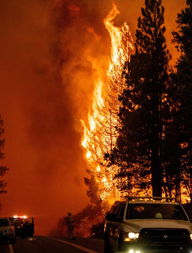
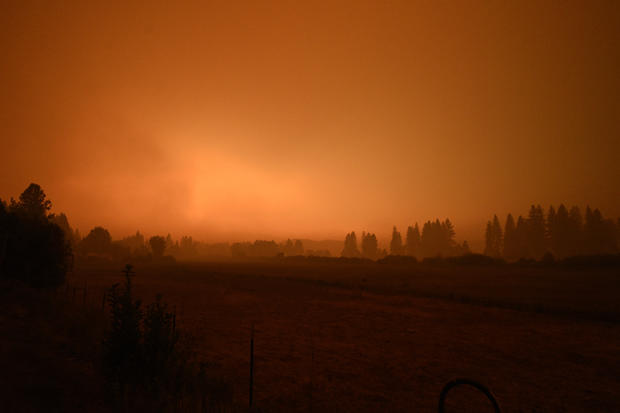
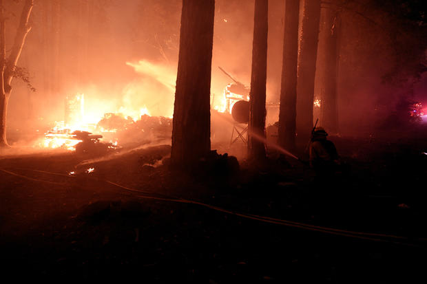
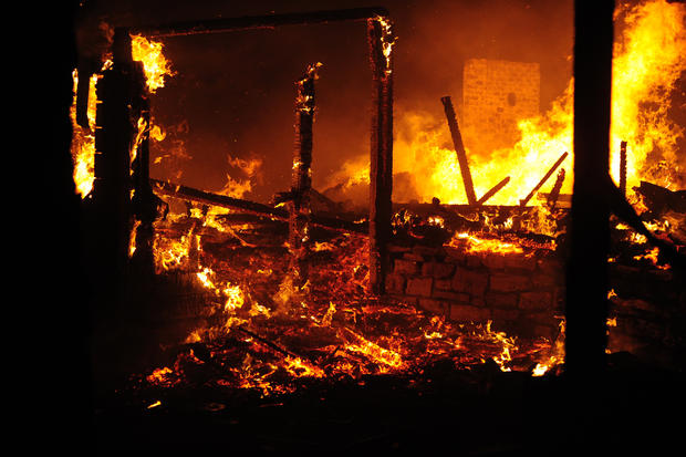
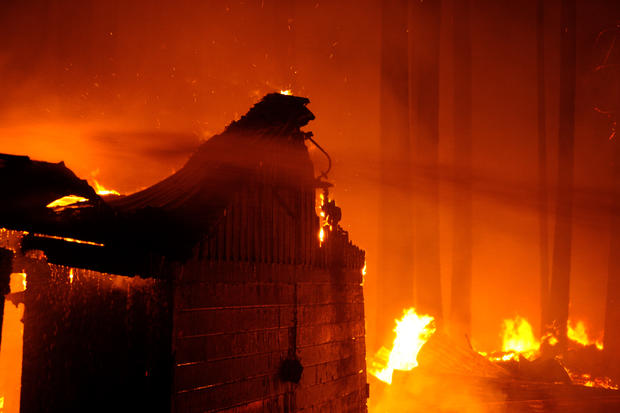
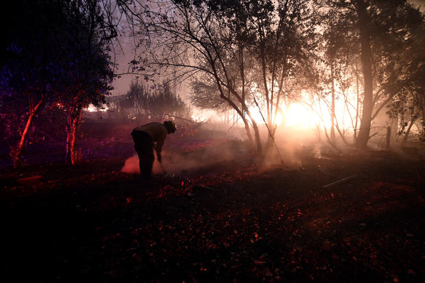
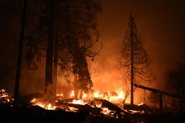
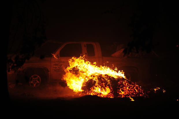
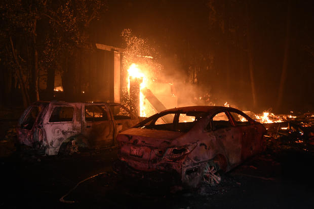
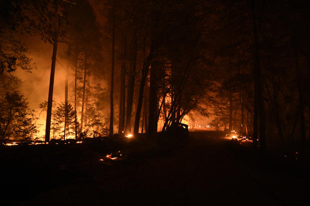
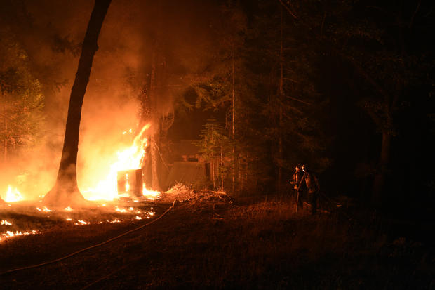
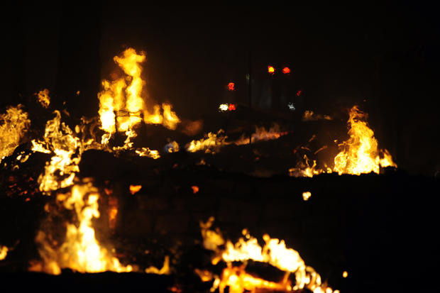
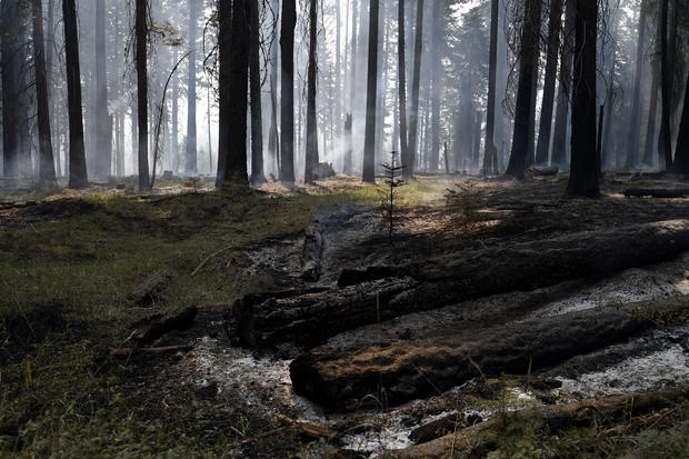
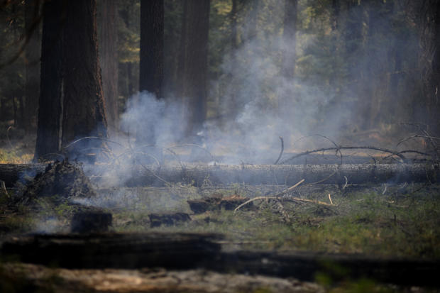
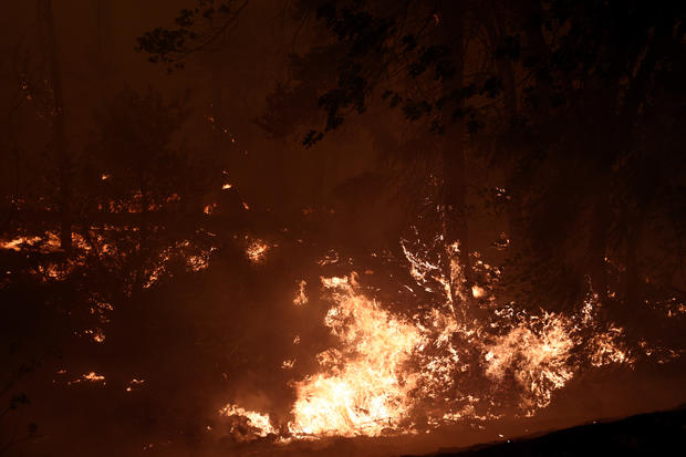
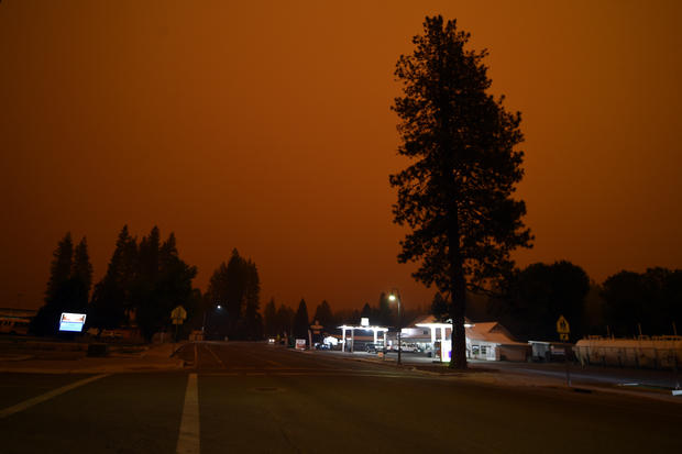
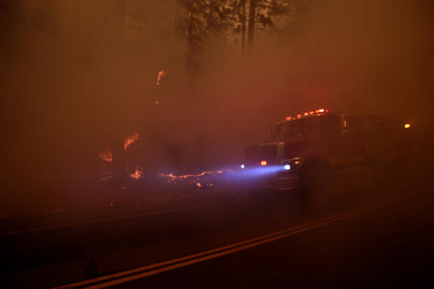
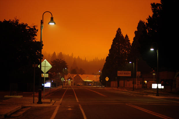
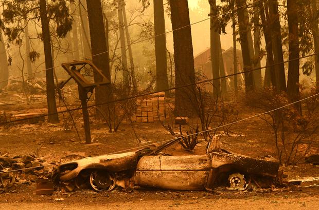
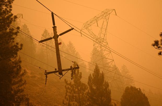
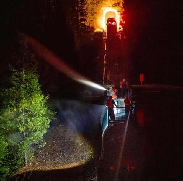
See photos of the Dixie Fire below.


12:50 p.m.
Overnight, the Dixie and Fly fires burning in Butte and Plumas counties burned together, making up an estimated 195,000 acres combined.
Just before noon Sunday, the Plumas County Sheriff's Office issued mandatory evacuation orders for all of Genesee Valley and northern and eastern parts of Indian Valley, with additional warnings to follow.
Cal Fire said more than 10,700 structures were threatened by flames and at least 16 structures have been destroyed. The agency said the fire remains highly active with long-range spotting and extreme rates of spread in a remote area with limited access and steep terrain.
See a time-lapse of Fly Fire in Plumas County here.
The Dixie Fire started on July 13 at 5:15 p.m. The cause of the fire is under investigation. On Saturday, it burned across both Highways 70 and 89, according to Cal Fire.
There are currently more than 4,200 personnel assigned to the fire, including many from the Sacramento area.
Saturday's updates below:
10:48 p.m.
Sacramento Metro Fire on Saturday said four firefighters are part of a task force assisting with the Dixie Fire.
According to Cal Fire's website, evacuations remain in place for the following areas.
- The west shore of Lake Almanor from the Canyon Dam northwest to Highway 36 at Highway 89. This includes Prattville, Big Meadows, and Lake Almanor West along with the Rocky Point Campground and the Canyon Dam Boat Launch.
- High Lakes Recreational Area in Plumas County east of the Butte-Plumas County line, as well as the Plumas-Butte County Line east to Twain, including both sides of Highway 70 in the areas of Rock Creek, Storrie, Tobin, Belden, Caribou Rich Bar, and Twain.
- Meadow Valley and Bucks Lake, Bucks Lake Road at Riverdance, and everything west to the Butte-Plumas County line, including Snake Lake, Meadow Valley, Tollgate, Bucks Lake, Bucks Lake Highlands, and all surrounding areas.
- Caribou Road north to the Humbug Road and Humboldt Road intersection, including Belden and Butt Valley reservoirs, Prattville, Butt Reservoir Road, and everything west to the Butte/Plumas County line, and the community of Seneca south to Highway 70.
- The Paxton, Seneca, Long Valley, and East Butt Lake areas. Evacuation Warning to include the Paxton area at State Route 70 north to the Long Valley, west to the south side of Butt Lake, from the south side of Butt Lake to SR70 at Virgilia, east along the north edge of the SR70 corridor to Paxton.
- In the Long Valley and Seneca communities, starting from the Long Valley area north along Wolf Creek Road to the intersection of Wolf Creek Road and South Almanor, from the intersection of South Almanor and Wolf Creek Road west along South Almanor, continuing west along Fox Farm Road to the intersection of Humbug-Humboldt Crossing Road, from the intersection of Fox Farm Road and Humbug-Humboldt Road, to south along Prattville Butt Valley Reservoir Road.
More evacuation orders and warning information can be found here.
12:56 p.m.
Mandatory evacuation orders have been issued in the Dixie Fire which has grown to 181,289 acres and is 19% contained. Ten structures have been destroyed and 7,010 structures are threatened.
Just before 1 p.m., the Plumas County Sheriff's Office ordered a mandatory evacuation for residents on the north side of Chandler Road, from Oakland Camp Road to Highway 70 east.
On Friday, Cal Fire issued an update detailing all of the regions under evacuation orders and those under evacuation warnings.
Friday's updates below:
5:45 p.m.
A virtual community meeting is being held at 7 p.m. regarding the Dixie Fire. Here is the Zoom meeting link:
us02web.zoom.us/j/81721688745 USA 215-446-3649 Conference code: 746758 USA 888-557-8511 (US Free) Conference code: 746758
4:11 p.m.
Butte County has issued some information about their evacuation center and animal shelter. The evacuation center is at the Church of the Nazarene, which is at 2238 Monte Vista Avenue in Oroville.
The shelter (for small animals) is at Old County Hospital, which is at 2279 Del Oro and Mono Ste. E in Oroville at 3:45 p.m.
2:51 p.m.
An Evacuation Order has now been issued for the Butte Meadows area.
The order was previously an Evacuation Warning, according to the Butte County Sheriff's Office.
An evacuation warning is in effect for Quincy, meaning that people need to be ready to evacuate if they are ordered to.
1:42 p.m.
With the Dixie Fire continuing to grow, smoke from the massive blaze is now drifting down into the Sacramento Valley.
Several agencies across the valley - including El Dorado Hills, Folsom and Rocklin - have posted advisories early Friday morning, alerting residents that the smoke they may be seeing is not from any active fires in their area at the moment.
People are being urged to limit their outdoor activities for the time being due to the smoke.
According to National Weather Service forecasts, it appears the smoke will eventually move out by Friday night.
8:29 a.m.
The Dixie Fire continued to grow overnight, with the wildfire now at 142,940 acres.
Containment inched up to 18 percent as well, firefighters report.
Firefighters say the flames are continuing to move north and northeast, with there still being the potential for 2-3 more miles of new growth.
Thursday's updates below:
10:13 p.m.
Firefighters are going door to door in Greenville and Crescent Mills urging people to evacuate to the Springs of Hope church in Quincy.
The Dixie Fire is now over 103,000 acres. Cal Fire warns fire conditions will be bad the next three days.
5:55 p.m.
More evacuation orders have been issued for Plumas County.
The following Mandatory Evacuation Orders are now in effect:
Chandler Road from Highway 70 at Chandler Road west to Oakland Camp.
People are being urged to leave immediately.
Evacuees should drive eastbound to 59 Bell Lane in Quincy, the Plumas County Sheriff's Office says.
4:33 p.m.
New evacuation orders have been issued in Plumas County.
According to the Plumas County Sheriff's Office, the following areas are now under Mandatory Evacuation Orders:
Greenville and Crescent Mills, Round Valley Reservoir, Dixie Canyon, Indian Falls, Long Valley (west of Round Valley), Dixie Canyon south to Indian Falls, south of Indian Falls to the Hwy 70/89 Junction, Highway 70 at Black Hawk Rd north to the Highway 70/89 Junction. Also, everything on the western side of Highway 70, including Butterfly Valley, and Black Hawk.
The orders have been prompted due to a spot fire from the Dixie Fire as well as the forward progression of the incident, which remains only 17 percent contained as of Thursday afternoon.
The sheriff's office says personnel are going door-to-door to make the evacuation notices.
10:15 a.m.
The Dixie Fire has now burned 103,910 acres as of Thursday morning, Cal Fire reports.
Firefighters say they are continuing to aggressively battle the flames, which are still moving northeast. Limited access and steep terrain remains a problem for crews.
While the incident has now been burning for a week, slightly more containment is also now being reported. After days of being stuck at 15 percent, Cal Fire reported on Thursday that containment is now up to 17 percent.
Numerous evacuation orders still remain in effect in Butte, Lassen and Plumas counties.
Wednesday night, Cal Fire confirmed that at least eight structures had been destroyed by the Dixie Fire so far. It's unclear if any of those structures were homes, however.
Wednesday's updates below:
9:25 p.m.
According to Cal Fire, at least eight structures have been destroyed by the Dixie Fire. The agency said it could not confirm yet if any of the structures were homes.
As of Wednesday night, the fire has grown to 91,268 acres and was still 15% contained.
8:46 a.m.
The Dixie Fire burning in Butte County has now grown to 85,479 acres as of Wednesday morning, Cal Fire reports.
Containment still stands at 15 percent, the number it has been stuck at since the weekend.
Firefighters reported that the wildfire remained active overnight. Cal Fire says the wildfire is continuing to move northeast, with 2-3 miles of area possibly being burned.
Existing control lines from the previous Bear and Chips fires are helping firefighters, as the Dixie Fire is now well established in that previous burn scar.
Several evacuation orders and warnings remain in effect in both Butte and Lassen counties.
Tuesday's updates below:
7:40 p.m.
As of Tuesday evening, the Dixi has burned 61,376 acres and containment was still at 15%, according to Cal Fire.
The agency said 810 structures remain threatened by the fire, and so far, two structures have been destroyed.
7:43 a.m.
The Dixie Fire continued to grow overnight, with Cal Fire reporting that size had jumped to 59,984 acres as of Tuesday morning.
Containment still stands at 15 percent, the same as it was on Monday.
Firefighters say the flames are continuing to move to the east and north. With isolated thunderstorms possible Tuesday afternoon into the evening, firefighters are also concerned for new starts.
Evacuation orders remain unchanged since Monday.
Hard closures of Highway 70 at Deadwood and Bucks Lake Road at Plains Road also remain in effect.
Monday's updates below:
9:15 p.m.
Cal Fire said Monday night that the Dixie Fire in Butte County has grown to burn 40,500 acres and was still 15% contained. The agency said crews will continue to work through the night on widening and strengthening control lines that are in place.
Though it was an active day overall for the fire, Cal Fire warns that the area may experience isolated thunderstorms. Lightning strikes have already been the cause of several wildfires throughout Northern California.
6:55 p.m.
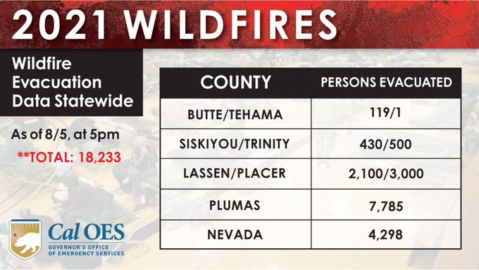
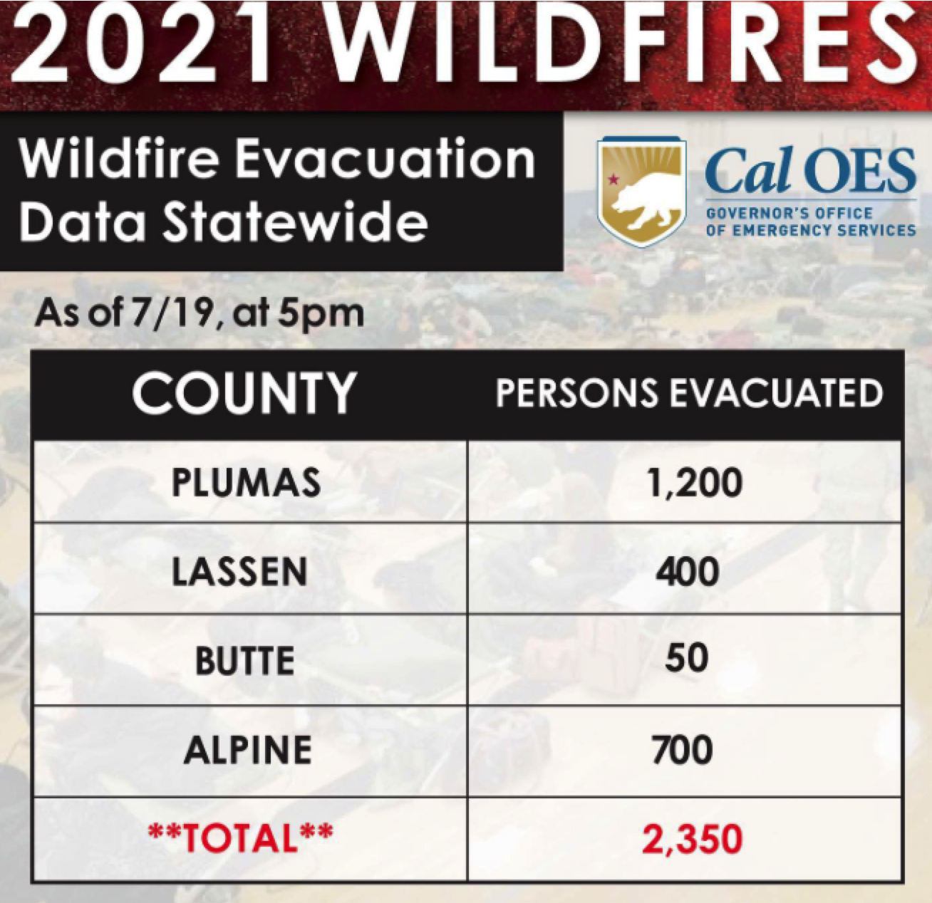 The California Office of Emergency Services released data Monday evening on how many people were evacuated due to wildfires in the state. Due to the Dixie Fire, approximately 1,250 people were evacuated from their homes in Butte and Plumas counties.
Evacuation orders from the weekend were still in place for the High Lakes Recreational Area in Plumas County east of the Butte-Plumas County line, as well as the Plumas-Butte County Line east to Twain, including both sides of Highway 70 in the areas of Rock Creek, Storrie, Tobin, Belden, Caribou Rich Bar, and Twain. Mandatory evacuations are also in place for the areas of Meadow Valley and Bucks Lake, including Bucks Lake Road at Snake Lake Road and west to the Plumas-Butte County line, including the area of Tollgate.
On Monday new, evacuation orders were issued for the area from Twain east to Paxton and the Greenville Wye (Highway 89 at Highway 70) and the community of Seneca and the area south of it to Highway 70.
Evacuation warnings are also in place for the Butte Meadows and Inskip areas.
6:00 p.m.
Evacuation orders now include the area from Twain east to Paxton and the Greenville Wye (Highway 89 at Highway 70), authorities said.
3:52 p.m.
The Plumas County Sheriff's Office said mandatory evacuations for the Dixie Fire have been expanded to include the community of Seneca and the area south of it to Highway 70. Residents should leave immediately.
As of Monday, the Dixie Fire has burned 30,074 acres and was still at 15% containment.
Evacuation orders remain in place for the High Lakes Recreational Area in Plumas County east of the Butte-Plumas County line, as well as the Plumas-Butte County Line east to Twain, including both sides of Highway 70 in the areas of Rock Creek, Storrie, Tobin, Belden, Caribou Rich Bar, and Twain. Mandatory evacuations are also in place for the areas of Meadow Valley and Bucks Lake, including Bucks Lake Road at Snake Lake Road and west to the Plumas-Butte County line, including the area of Tollgate.
Evacuation warnings are also in place for the Butte Meadows and Inskip areas.
Additionally, Pacific Gas & Electric Company says its equipment was possibly involved in the start of the now 30,000-plus acre Dixie Fire.
Sunday's updates
8:50 p.m.
Cal Fire said Sunday night that the Dixie Fire has grown to burn 18,702 acres, while containment was still at 15%. There was "significant fire activity" Sunday and the flames continued moving southeast toward Bucks Lake, the agency said.
According to Cal Fire, 810 structures are threatened by the fire. No structures have been destroyed and there have been no other injuries reported.
6:33 p.m.
More evacuations have been ordered as a result of the Dixie Fire burning in Butte County.
The Butte County Sheriff's Office has ordered mandatory evacuations for the areas of Jonesville and Philbrook.
According to Cal Fire, the Dixie Fire has scorched more than 15,000 acres and was 15% contained.
Evacuation orders are also still in place for multiple areas in nearby Plumas County, including High Lakes from Rock Creek to Tobin. Additionally, evacuation warnings are in place for the Butte Meadows and Inskip areas, and the area east of the Rock Creek Dam to Caribou, including both sides of Highway 70 in the area. Highway 70 in the area is closed.
One firefighter suffered minor injuries during Thursday's firefight, according to Cal Fire. This was the only injury reported so far in the Dixie Fire. Cal Fire said the firefighter was able to walk away.
(© Copyright 2021 CBS Broadcasting Inc. All Rights Reserved. The Associated Press contributed to this report.)