King Fire Update: Blaze Encroaching On Highway 50 As Crews Fight To Keep It From Jumping
10 p.m. Update: Click Here
8:30 p.m. UPDATE: The battle line right now is Highway 50. The blaze has burned right up to the four-lane highway, meaning road closures in the area are possible. There is a significant risk of embers crossing the highway and heading toward homes across the way. Crews are currently trying to stop the spread at the highway.
6:30 p.m. UPDATE: Pollock Pines Schools will remain closed on Wednesday after district advised not to re-open.
Although it was previously reported that classes would recommence tomorrow, Wednesday, September 17, the Pollock Pines Elementary School District has now been advised to remain closed due to the growing and unpredictable King Fire. According to Sergeant Jim Beyers, Director of the Emergency Operations Center – El Dorado Sheriff Department, "While the initial recommendation and advice to the Pollock Pines School District was to reopen for school tomorrow, based on the current changing fire behavior that has happened this afternoon, both the Office of Emergency Services and the King Fire Incident Command have now strongly recommended that the schools in Pollock Pines not reopen tomorrow, Wednesday, September 17. The situation will be reevaluated tomorrow afternoon."
The district is working closely with the Office of Emergency Services to ensure student and family safety. "Regardless of what happens, in any situation, we will always do what is in the best interest of our students and keep them safe," said Superintendent Kevin Monsma. "If that means changing gears at the last minute to do what is necessary, so be it."
The district remains in close contact with incident command and the Office of Emergency Services and will keep families and the community updated through their website http://www.ppesd.org/
3:30 p.m. UPDATE: Mandatory evacuation orders are in place for the following:
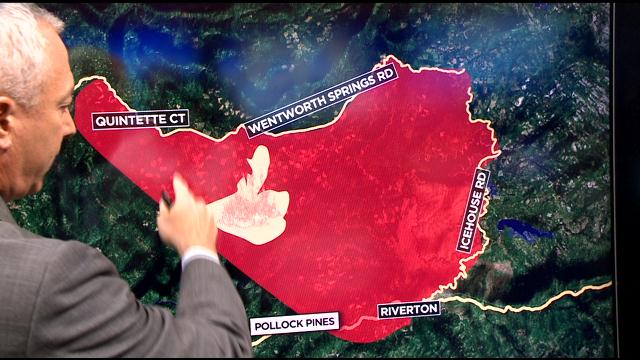
- Union Valley Reservoir area
- Yellow Jacket Campground
- Wolf Creek Campground
- Stumpy Meadows Campground
- Fashoda Campground
- Big Hill Lookout Road
- Big Hill Road
- Blodgett Forest Road
- Bridle Path Way
- Forest Road
- Frontier Road
- Helix Flat Ave
- Icehouse Road (west side)
- Jones Fork Power House Road
- Middle Loop Road
- Mosquito Road
- Onion Valley Road
- Outer Limits Lane
- Little Silver Road
- Loop Road
- Peavine Point Road
- Peavine Ridge Road
- Plum Creek Road
- Piolet Creek Road
- Robbs Peak Road
- Sand Mountain Road
- SMUDEA
- Spring Road
- Sunset Drive
- Tricometric Trail
- Wentworth Springs (south side, east of Pilot Creek Road)
- 11 Pines Road
----
EL DORADO COUNTY (CBS13/AP) — Nearly a dozen wildfires are burning through thousands of acres across California, destroying dozens of homes and forcing hundreds from their homes.
The King Fire in El Dorado County has burned more than 11,000 acres and fell to 5 percent containment as it threatens 500 homes.
As the flames pushed closer and closer to Highway 50, more families were forced to pack up and head out in a hurry.
Evacuees Maria and her husband Pancho say they'll spend an extremely nervous night in a motel away from the Sly Park home they fear is in the King Fire's path.
Crews worked to clear dense brush that could potentially fuel the fire that more than doubled in size on another hot, windy El Dorado County day.
While the fire is making runs northeast into largely unpopulated forest land, Cal Fire says the main concern remains Highway 50 and communities like Pollock Pines and Sly Park on the other side.
Firefighters are gaining ground on a wildfire that raced through a far Northern California town, damaging or destroying 100 homes and a church.
State fire spokeswoman Suzi Brady said Tuesday morning that the fire in the town of Weed near the Oregon border was 20 percent contained. There were no flames or smoke visible.
The fire has burned through 375 acres since it began Monday afternoon and showed almost no growth overnight.
Officials have said it moved quickly, catching residents off guard in the scenic town of nearly 3,000 near the base of Mount Shasta in the Cascade Mountains. At least 1,500 people were forced to flee.
Related articles


(TM and © Copyright 2010 CBS Radio Inc. and its relevant subsidiaries. CBS RADIO and EYE Logo TM and Copyright 2010 CBS Broadcasting Inc. Used under license. All Rights Reserved. This material may not be published, broadcast, rewritten, or Redistributed. The Associated Press contributed to this report.)